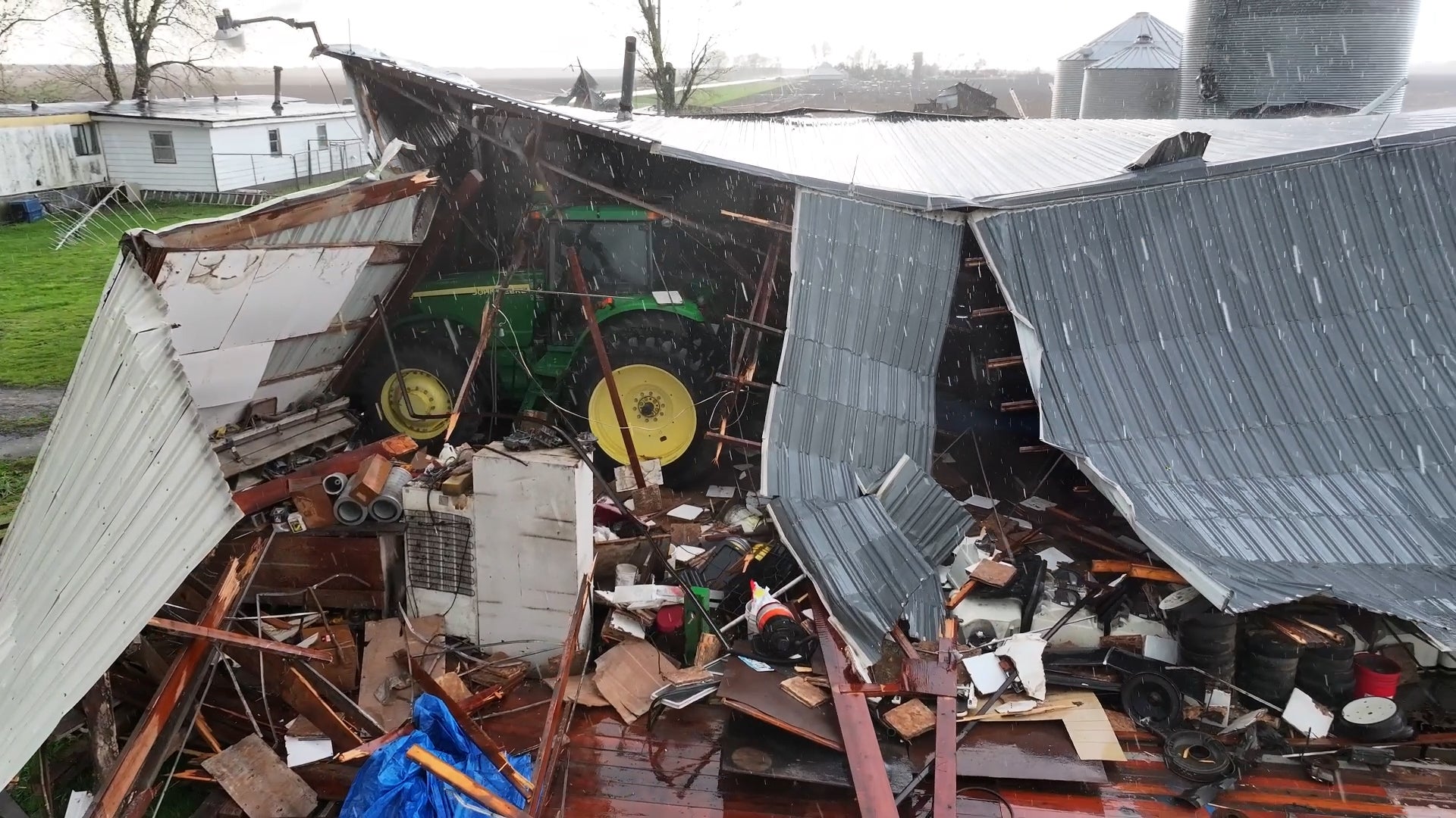
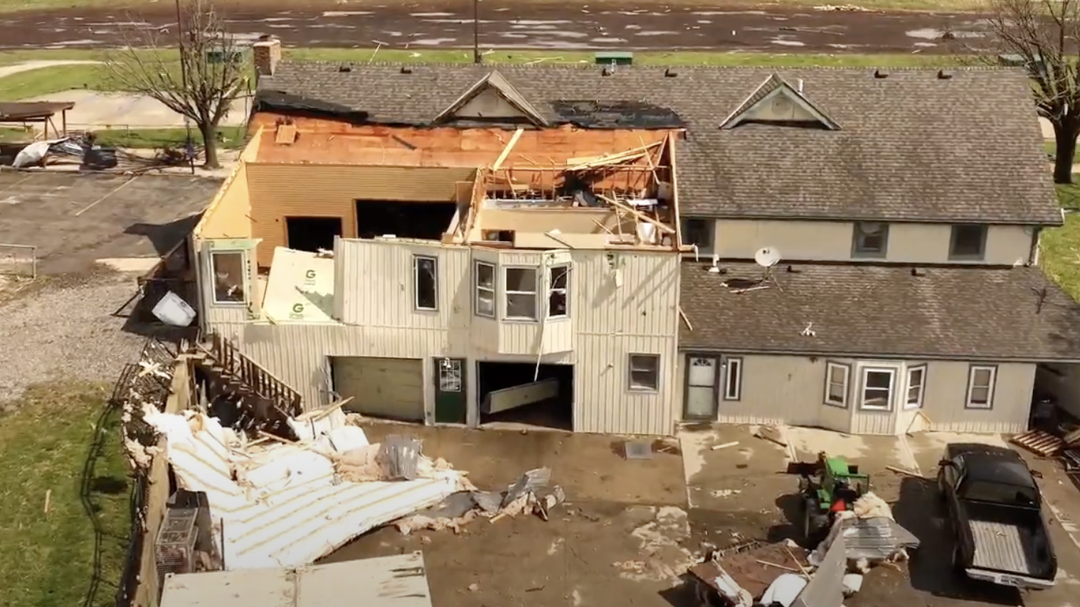
Dr. Jeff Masters' WunderBlog

Ana and TD 3 take aim at the Lesser Antilles
Posted by: Dr. Jeff Masters, 16:17 GMT le 15 août 2009 +7
Tropical Storm Ana was born this morning, when the remnants of Tropical Depression Two made a comeback and organized into the first tropical storm of the 2009 Atlantic hurricane season. Ana is the latest first named storm of the season since Hurricane Andrew got its name on August 17, 1992. The two storms have some similarities, as Andrew formed in the same part of the ocean, and also struggled in its early days with high wind shear and dry air. Let's hope the similarities end there.

Ana is struggling this afternoon. After an modest burst of heavy thunderstorm activity prompted NHC to upgrade Ana to a tropical storm early this morning, Ana has run into strong upper-level winds from the west that are creating high wind shear. This shear was not forecast, and it is not clear how long it will last. The shear has acted to drive dry air into the core of Ana, destroying almost all of Ana's heavy thunderstorms. The low-level center of the storm is now exposed to view, something that often foreshadows the death of a storm. It is possible the shear will destroy Ana, and several models (the GFS and ECMWF) forecast this may be the case. However, the shear forecast calls for shear to drop into the low range, 5 - 10 knots, tonight through Tuesday. If the shear does drop as forecast, Ana should be able to moisten the atmosphere around it sufficiently to protest itself from the dry Saharan air that surrounds it (Figure 1). SSTs are 27°C today, and will increase to 28°C by Sunday. By the time Ana moves into the Bahamas, total ocean heat content rises steeply (Figure 2), and rapid intensification of Ana is possible, if the shear and dry air haven't disrupted the storm. The intensity forecast models, for the most part, predict a steady intensification of Ana to the threshold of hurricane strength five days from now. The HWRF model is on the strong side, predicting a Category 2 hurricane. The GFDL predicts a weak tropical storm five days from now, but that is because the model has Ana passing over the rugged terrain of Hispaniola, something the other models do not predict. In summary, the intensity forecast for Ana has higher than usual uncertainty, and I give equal chances that the storm will be a hurricane--or non-existent--four days from now.


Figure 1. Water vapor image from this morning showing the large area of dry, Saharan air surrounding Ana, and lying to the north of Tropical Depression Three. Image credit: NOAA/SSD

Tropical Depression Three forms, could be Bill later today
QuikSCAT data from this morning and satellite loops revealed that the tropical wave (90L) in the middle Atlantic has finally developed a well developed surface circulation and can be classified as Tropical Depression Three. Recent satellite imagery suggests that TD 3 may already be Tropical Storm Bill. Water vapor imagery (Figure 1) shows that TD 3's center consolidated a few hundred miles south of the dry air of the Saharan Air Layer (SAL). Thus, the storm should not be affected by dry air and dust as much as Ana has been. Ana may also act to moisten the atmosphere in front of TD 3, helping protect the storm from the SAL as it edges farther north over the the three days.


Figure 2. Heat content of the ocean, in kJ per square cm. Oceanic heat content steadily increases for Ana and TD 3 as they approach the Lesser Antilles Islands. Oceanic heat content levels of 90 kJ per square cm are frequently associated with rapid intensification of hurricanes. Image credit: University of Miami.

Wind shear is moderate, 15 knots, but is forecast to fall to 10 - 15 knots on days 2 - 5. Sea Surface Temperatures are about 27.5°C, and will remain in the 27.5 - 28°C range the next five days. The combination of low wind shear and sufficiently warm SSTs should allow TD 3 to intensify steadily, and I expect the storm will be at hurricane strength by Wednesday, when it will be near the northern Lesser Antilles Islands. Most of our reliable intensity models strengthen TD 3 into a hurricane by Wednesday. Oceanic heat content (Figure 2) increases sharply just before the islands, so TD 3 could be intensifying rapidly as it moves through or just north of the Lesser Antilles on Thursday. TD 3 consolidated farther south than expected, so the track models calling for a more northerly path were probably incorrect. In particular, the ECMWF model, which had TD 3 turning sharply northwestward and missing the Lesser Antilles Islands, was probably much too far to the north in this morning's 00Z run. TD 3 will probably pass very close to the northern Lesser Antilles islands on Wednesday and Thursday.

I'll have an update Sunday.

Jeff Masters
Categories: Hurricane
  Permalink | A A A
Reader Comments
Display: 0, 50, 100, 200 Sort: Newest First - Order Posted
Viewing: 1301 - 1351

Page: 1 | 2 | 3 | 4 | 5 | 6 | 7 | 8 | 9 | 10 | 11 | 12 | 13 | 14 | 15 | 16 | 17 | 18 | 19 | 20 | 21 | 22 | 23 | 24 | 25 | 26 | 27 | 28 | 29 | 30 | 31 | 32 | 33 | 34 | 35 | 36 | 37 | 38 | 39 | 40 | 41 | 42 | 43 | 44 | 45 | 46 | 47 | 48 | 49 | 50 | 51 | 52 | 53 | 54 | 55 | 56 | 57 | 58 | 59 | 60 | 61 | 62 | 63 | 64 | 65 | 66 | 67 | 68 | 69 | 70 | 71 | 72 | 73 | 74 | 75 | 76 | 77 | 78 | 79 | 80 | 81 | 82 | 83 | 84 | 85 | 86 | 87 | 88 | 89 | 90 | 91 | 92 | 93 | 94 | 95 | 96 | 97Blog Index

1301. RescueAFR 21:34 GMT le 15 août 2009    
Good evening...From South Fla..
Do I read the GFS and GDL correct, South Fla appears out of the woods?....at the moment for both of these storms?
Member Since: 4 septembre 2008 Posts: 0 Comments: 79
1302. weathersp 21:35 GMT le 15 août 2009    
NOAA 49 has sent its first sonde back..
Member Since: 14 janvier 2007 Posts: 17 Comments: 4112
1303. WPBHurricane05 21:35 GMT le 15 août 2009    
Quoting RescueAFR:
Good evening...From South Fla..
Do I read the GFS and GDL correct, South Fla appears out of the woods?....at the moment for both of these storms?


Ummm...NO!
Member Since: 31 juillet 2006 Posts: 56 Comments: 7929
1305. rareaire 21:36 GMT le 15 août 2009    
Quoting 92Andrew:


No. I am not tempered. It is just the sort of homophobia that makes such people an outdated person living in a 21st century western country.


2nd time youve mentioned homophobia out of that entire rant.?? can we please quit quoting it and move on!
Member Since: 19 août 2007 Posts: 0 Comments: 1598
1306. FloridaTigers 21:36 GMT le 15 août 2009    
Quoting RescueAFR:
Good evening...From South Fla..
Do I read the GFS and GDL correct, South Fla appears out of the woods?....at the moment for both of these storms?


Not at all. There is no such thing as out of the woods if you're in the cone.
Member Since: 17 mai 2009 Posts: 0 Comments: 559
1308. JupiterFL 21:36 GMT le 15 août 2009    
Quoting ssmate:
Poll Time:

1) A
2) B
3) C
4) D

I'll tally up all the votes in 20 minutes.


best poll ever....
Member Since: 10 août 2005 Posts: 0 Comments: 2146
1309. stormwatcherCI 21:37 GMT le 15 août 2009    
Quoting RescueAFR:
Good evening...From South Fla..
Do I read the GFS and GDL correct, South Fla appears out of the woods?....at the moment for both of these storms?
You said it. At the moment. Time will tell.
Member Since: 9 octobre 2008 Posts: 0 Comments: 8043
1311. BrandiQ 21:38 GMT le 15 août 2009    
Can some please post the link to the GFS model.
Member Since: 25 mai 2009 Posts: 0 Comments: 155
1312. mojofearless 21:38 GMT le 15 août 2009    
Hello y'all. I've been lurking here for over a year now, and thought I'd finally log in. I've grown so e-fond of some of you... Storm, Weather Student, Keeper of the Gate, etc. I've learned a lot, and appreciate it. Definitely gives me an edge here in New Orleans. Should be an interesting week.
Member Since: 13 août 2009 Posts: 0 Comments: 170
1313. stormwatcherCI 21:38 GMT le 15 août 2009    
Quoting stormpetrol:

You know what you are, I'll give you a hint, Its looks just your avatar!!!
ROFLMAO
Member Since: 9 octobre 2008 Posts: 0 Comments: 8043
1314. Patrap 21:38 GMT le 15 août 2009    
Member Since: 3 juillet 2005 Posts: 372 Comments: 111626
1315. jipmg 21:39 GMT le 15 août 2009    
alright so can I have a link to the forecast models
1316. foggymyst 21:39 GMT le 15 août 2009    
Nat' weather service for Miami area states tropical storm conditions for wednesday night..
Member Since: 23 septembre 2008 Posts: 0 Comments: 383
1317. wunderkidcayman 21:40 GMT le 15 août 2009    
Quoting weathersp:
NOAA 49 has sent its first sonde back..

please help me with that I am on the tropical atlantic recon site
Member Since: 13 juin 2009 Posts: 2 Comments: 5500
1318. JupiterFL 21:40 GMT le 15 août 2009    
Quoting stormpetrol:

You know what you are, I'll give you a hint, Its looks just your avatar!!!


Perfect...
Member Since: 10 août 2005 Posts: 0 Comments: 2146
1319. forestwedder 21:40 GMT le 15 août 2009    
Quoting java162:


i think bill is way too south for it to go all the way to the north( ignoring steering paterns)


Definetly with you on that.
Member Since: 18 juillet 2009 Posts: 0 Comments: 25
1320. stormpetrol 21:40 GMT le 15 août 2009    
Quoting stormwatcherCI:
ROFLMAO

Sorry I just couldn't help it, I see so much bull here this evening the flies are starting to gather on my monitor again.
Member Since: 29 avril 2007 Posts: 0 Comments: 6404
1322. MILLERTIME1 21:40 GMT le 15 août 2009    
By Kingfan104. Have a nice life.Admin???
Member Since: 13 août 2009 Posts: 0 Comments: 65
1323. boomerang08 21:41 GMT le 15 août 2009    
does anyone have a link to the models that go out 200+ hrs?
1324. RescueAFR 21:42 GMT le 15 août 2009    
Quoting stormwatcherCI:
You said it. At the moment. Time will tell.

Excellent...it would be sweet if those moments turn to hours then to days....Gotta love living in the tropics...
Member Since: 4 septembre 2008 Posts: 0 Comments: 79
1325. jipmg 21:42 GMT le 15 août 2009    
Im starting to disagree with the models.. some of them have ana moving West or WSW in the short term when the thing is currently moving north of due west..
1327. jurakantaino 21:43 GMT le 15 août 2009    
Quoting Funkadelic:
Newer models have shifted a tad west for Bill.. Here take a look:


Link
Bad News for us in Puerto Rico and V.I.
Member Since: 31 juillet 2008 Posts: 0 Comments: 730
1328. serialteg 21:43 GMT le 15 août 2009    
Quoting P451:


Surface Wind Streamlines 21Z


that "blob" sure looks uglier by the minute.
Member Since: 22 août 2006 Posts: 2 Comments: 1966
1329. gtownTX 21:44 GMT le 15 août 2009    
Just one of the millions of earthlings who pay attention to weather and learning what I can. Storm tracking seems a lot like trying to nail Jello to the wall.....

Anyway I was wondering...why so many different models with different conclusions? Is one more reliable than another?
Member Since: 14 juillet 2009 Posts: 0 Comments: 29
1330. RitaEvac 21:44 GMT le 15 août 2009    
NHC putting track now West of Florida Keys...too far out folks, but you get the drift, more and more west means one thing, GULF storm
Member Since: 14 juillet 2008 Posts: 1 Comments: 8912
1332. serialteg 21:44 GMT le 15 août 2009    
Quoting jurakantaino:
Bad News for us in Puerto Rico and V.I.


then again...


which is why...
Member Since: 22 août 2006 Posts: 2 Comments: 1966
1333. BrandiQ 21:46 GMT le 15 août 2009    
Quoting jurakantaino:
Bad News for us in Puerto Rico and V.I.


The link doesn't work.
Member Since: 25 mai 2009 Posts: 0 Comments: 155
1334. JupiterFL 21:44 GMT le 15 août 2009    
Quoting BrandiQ:
Can some please post the link to the GFS model.


http://moe.met.fsu.edu/cgi-bin/gfstc2.cgi?time=2009081512&field=850mb+Vorticity&hour=Animation
Member Since: 10 août 2005 Posts: 0 Comments: 2146
1335. aspectre 21:45 GMT le 15 août 2009    
1152 wunderkidcayman "did anyone found out that now TS ANA is moving faster than TS BILL"

Yep, been tracking their positions to see if the two would get close*enough to begin watching for the mutual interaction which would pull TSAna south and TSBill north.
Instead they've gotten 0.37degrees farther apart to nearly 15degrees of separation.
And to cap it off, TSAna has a northerward component in its mostly westward movement, while TSBill has a southward component to its mostly westward movement.

* Less than 13degrees separation
Member Since: 21 août 2007 Posts: 0 Comments: 4846
1336. stormwatcherCI 21:45 GMT le 15 août 2009    
Quoting stormpetrol:

Sorry I just couldn't help it, I see so much bull here this evening the flies are starting to gather on my monitor again.
And with him on here they will gather even faster(with his "Avatar")
Member Since: 9 octobre 2008 Posts: 0 Comments: 8043
1337. serialteg 21:45 GMT le 15 août 2009    
Quoting RescueAFR:

Excellent...it would be sweet if those moments turn to hours then to days....Gotta love living in the tropics...


WORD
Member Since: 22 août 2006 Posts: 2 Comments: 1966
1338. Gumbogator 21:45 GMT le 15 août 2009    
It's way too early to put much stock in any long range track or intensity forecast for either Ana or Bill. Let the speculation and games begin!! Gas prices are surely gonna geaux up in the next week*** "Greed is good." Gordon Gecko..........not!!
Member Since: 21 août 2008 Posts: 0 Comments: 97
1339. Patrap 21:45 GMT le 15 août 2009    
T S Bill Enhanced Infrared (IR) Imagery (4 km Mercator)

Time of Latest Image: 20090815 2045 UTC


4km Remapped Color Enhanced Infrared Imagery

Current imagery and loops of 4km remapped and color enhanced infrared (IR) imagery is displayed in an earth fixed coordinate system. IR imagery (~11 um) from five geostationary satellites are remapped to a common 4km resolution Mercator projection in an identical manner as the CIRA Tropical Cyclone Image Archive described in (Mueller et al. (2006) . These images are then centered and displayed using the nearest 5 degree latitude/longitude earth coordinate based on the most recent location and past 12-h movement. The images are also color enhanced with the coldest temperatures/highest clouds displayed as colored shades as shown in this color bar.
Member Since: 3 juillet 2005 Posts: 372 Comments: 111626
1340. serialteg 21:46 GMT le 15 août 2009    
Quoting aspectre:
1152 wunderkidcayman "did anyone found out that now TS ANA is moving faster than TS BILL"

Yep, been tracking their positions to see if the two would get close enough to begin watching for the mutual interaction which would pull TSAna south and TSBill north.
Instead they've gotten 0.37degrees farther apart to nearly 15degrees of separation.
And to cap it off, TSAna has a northerward component in its mostly westward movement, while TSBill has a southward component to its mostly westward movement.

* Less than 13degrees separation


ana doesnt have that much mass to begin with
Member Since: 22 août 2006 Posts: 2 Comments: 1966
1341. JLPR 21:46 GMT le 15 août 2009    
Quoting jurakantaino:
Bad News for us in Puerto Rico and V.I.


yep those look bad =\
Member Since: 4 septembre 2007 Posts: 36 Comments: 5223
1342. KEEPEROFTHEGATE (Mod) 21:46 GMT le 15 août 2009    
Member Since: 15 juillet 2006 Posts: 144 Comments: 40651
1343. BrandiQ 21:46 GMT le 15 août 2009    
Quoting JupiterFL:


http://moe.met.fsu.edu/cgi-bin/gfstc2.cgi?time=2009081512&field=850mb+Vorticity&hour=Animat ion


thanks!
Member Since: 25 mai 2009 Posts: 0 Comments: 155
1345. CaicosRetiredSailor 21:47 GMT le 15 août 2009    
Quoting jipmg:
alright so can I have a link to the forecast models


At the top of this page click on the link:
Tropical / Hurricane

http://www.wunderground.com/tropical/

Under:
Helpful Online Resources

See:
Computer model forecasts

for a list of Model sites.
Member Since: 12 juillet 2007 Posts: 0 Comments: 5138
1346. weatherblog 21:48 GMT le 15 août 2009    
Quoting RescueAFR:
Good evening...From South Fla..
Do I read the GFS and GDL correct, South Fla appears out of the woods?....at the moment for both of these storms?


We are definitely not out of the woods.

Anyways, the GOM shouldn't worry about Ana. If it were to head that way, it'll definitely die from passing over Cuba, Haiti, or the DR. The only threat this has it to the islands, the Bahamas, and Florida for now.
Member Since: 10 juillet 2006 Posts: 27 Comments: 1623
1347. surfsidesindy 21:48 GMT le 15 août 2009    
Quoting ssmate:
Poll Time:

1) A
2) B
3) C
4) D

I'll tally up all the votes in 20 minutes.

A hard choice, but I'd say definitely A
Member Since: 7 septembre 2005 Posts: 0 Comments: 287
1348. Movingforward 21:48 GMT le 15 août 2009    
Has there ever been another instance where two storms received their name on the same day? It's amazing that this has happened with the first two storms of the season!
1349. stormwatcherCI 21:48 GMT le 15 août 2009    
Quoting Patrap:
Not good for me, Stormpetrol,Kman,wunderkid etc if this pans out.
Member Since: 9 octobre 2008 Posts: 0 Comments: 8043
1350. stormwatcherCI 21:48 GMT le 15 août 2009    
Quoting surfsidesindy:

A hard choice, but I'd say definitely A
What was the question ?
Member Since: 9 octobre 2008 Posts: 0 Comments: 8043
1351. RitaEvac 21:49 GMT le 15 août 2009    
Bill may take a Gilbert path, and intensity. Jamaica, Yucatan wake up
Member Since: 14 juillet 2008 Posts: 1 Comments: 8912

Viewing: 1301 - 1351

Page: 1 | 2 | 3 | 4 | 5 | 6 | 7 | 8 | 9 | 10 | 11 | 12 | 13 | 14 | 15 | 16 | 17 | 18 | 19 | 20 | 21 | 22 | 23 | 24 | 25 | 26 | 27 | 28 | 29 | 30 | 31 | 32 | 33 | 34 | 35 | 36 | 37 | 38 | 39 | 40 | 41 | 42 | 43 | 44 | 45 | 46 | 47 | 48 | 49 | 50 | 51 | 52 | 53 | 54 | 55 | 56 | 57 | 58 | 59 | 60 | 61 | 62 | 63 | 64 | 65 | 66 | 67 | 68 | 69 | 70 | 71 | 72 | 73 | 74 | 75 | 76 | 77 | 78 | 79 | 80 | 81 | 82 | 83 | 84 | 85 | 86 | 87 | 88 | 89 | 90 | 91 | 92 | 93 | 94 | 95 | 96 | 97Blog Index

New Comment
Community Standards Policy Comments will take a few seconds to appear.
Post Your Comments
Please sign in to post comments.
Not only will you be able to leave comments on this blog, but you'll also have the ability to upload and share your photos in our Wunder Photos section.
About JeffMasters
Jeff co-founded the Weather Underground in 1995 while working on his Ph.D. He flew with the NOAA Hurricane Hunters from 1986-1990.

Local Weather
Clear
34 ° F
Ciel dégagé
Community Activity